Digital point clouds that have been laser-scanned are used by building information modeling (BIM) systems. Development, design, and construction teams can obtain the data as a 3D site or building model created by a workflow or procedure called “Scan to BIM solutions.” These swiftly assembled models offer precise visual perception and fine-grained spatial awareness. Automating most of the building documentation and reality capture process aids in site documentation for new construction projects; for renovation or adaptive reuse projects, it aids in gaining a comprehensive understanding of the existing infrastructure.
Scan to BIM solutions refers to the process of documenting an existing building so that it can be used with the Building Information Modeling (BIM) digital planning technique. With 3D laser scanning technology, a high-density point cloud of an actual building, structure, or site is acquired in order to develop and maintain a BIM model that accurately depicts the situation “As is.”
As-built documentation, project expansions and renovations, facility management, and other downstream applications are just a few of the uses for models made with scan to BIM solutions. Scan to BIM models are also highly useful for other purposes, such as topographic registration and comparison with original designs.
The “Scan to BIM solutions” approach builds a BIM model of an existing space or building using cutting-edge technologies like 3D laser scanning and high-definition photogrammetry. A digital survey processed using specialized software yields a final result known as a point cloud, or 3D mesh, which is a collection of points organized in three dimensions. A BIM modeling application can be used to import the point cloud and create digital models of the existing structure.
Table of Contents
How Scan to BIM Solutions Works
Similar to 3D photogrammetry, scan to BIM solutions may also be related to augmented reality in construction (AR) depending on how the 3D model is experienced. In just a few hours, the scan to BIM solutions process transforms a building or site’s visual, spatial appearance into a readable model with useful data, positioning it to take the role of numerous essential building and construction instruments, including the common tape measure.
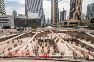
The initial phase of the scan to BIM solutions process involves mounting a laser scanner on an aerial drone, securing it to a tripod and allowing it to be moved about the site, or mounting it on a person as they walk around the site. In order to record points in space that match the geometry of the site, such as walls, doors, the ground plane, apertures, and more, the laser scanner tracks each point’s position along its x, y, and z axes.
The resulting point-cloud contains enormous amounts of data. 600 million points can be obtained from a five-minute scan; certain scanners can collect two million unique points per second. The laser scanner finds these spots by firing a light beam and timing how long it takes for it to bounce back and return. Lidar, or light detection and ranging, is the primary scanning method. Other scanners, on the other hand, use SLAM, or simultaneous localization and mapping, techniques, that enable the scanner to be found while the point-cloud map is being constructed.
Suggested article to read: What is Scan to BIM? Comprehensive Guide 2025
How Surveyors Benefit from Scan to BIM Solutions
One practical way to address the issues caused by outdated surveying and rebuilding techniques is to use Scan to BIM solutions. Surveyors and laser scanning organizations might benefit from numerous significant advantages. Scan to BIM has a number of benefits, including:
1. Precise Geographical Analysis
The evaluation of interdependencies across different crafts, such as architecture, structure, and MEPF, depends on spatial analysis. Building space division and element extraction are supported by a precise, well-coordinated, and clash-free 3D model. An enhanced visual representation of the spatial model is represented by an operational 3D model. Before building starts, thorough site mapping and accurate spatial analysis using data-enriched 3D models confirm the viability of the concept.
Suggested article to read: Clash Detection in BIM; Ultimate Guide 2025
2. Precise and Reliable Construction Cost Estimates
Accurate and comprehensive documentation of building structures is achieved by using laser scanners to capture every inch and crevice of a building’s architecture, structure, and MEPF system. Surveyors and cost estimators may determine precise costs for every building component by using the 3D as-built BIM model. They can drive economical maintenance by utilizing the 3D model’s as-built data.
3. Presence of 360-degree Visualization
Point Cloud to Revit BIM provides precise, comprehensive, and data-rich 3D models that enable 360-degree displays. Surveyors and architects may provide their clients with VR-ready walkthroughs of their 3D Point Cloud models so they can see each element in three dimensions. Surveyors can identify and fix problems early in a renovation or retrofit project by using 3D visualization. This encourages teamwork, thoughtful decision-making, and prompt action.
4. Reduced Design Risks
Errors in design can be extremely dangerous when remodeling or renovating. Historic sites are very important architecturally. To replicate original conditions, artifacts, elements, or equipment inside a heritage structure must be kept. Renovating or remodeling complex heritage architecture, where MEP systems are installed and functional within the building, is very vulnerable to the risks posed by legacy procedures and instruments.
In these situations, using data-rich 3D models with Point Cloud to BIM modeling for renovation and retrofit projects improves design visibility and validity. Design hazards and conflicts are minimized when parts within the building are placed or positioned correctly. To provide the greatest possible design, parametric 3D modeling and generative design promote precise and effective design prototypes.
Suggested article to read: Scan to BIM Software; Ultimate Guide for Point Cloud to BIM Modelling
5. Improved Operational Efficiencies
Among the operational efficiencies of Scan to BIM solutions are economical methods for producing high-quality building products. Optimized production resources should minimize overproduction, minimize excess material consumption, minimize site waste, and mitigate product or service failures.
The number of times surveying staff must visit the project site to conduct surveys is decreased when plans and designs are based on data from laser scanning. Reducing downtime and field rework by capturing every feature in a 3D model constructed from a point cloud.
6. Lower Health and Safety Hazards
Risks to health and safety that arise during building are a major concern for the construction sector. There is limited and imprecise visualization of places, dimensions, tools, or materials when using 2D designs. Using outdated tools while renovating high-rise buildings or monuments in difficult-to-reach areas can pose a safety risk.
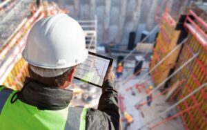
Field staff can view a full representation of every area and corner from a tablet-sized device with Scan to BIM solutions. Site safety risks are reduced by equipment specifications and annotations in a 3D model made in accordance with safety compliance standards.
Suggested article to read: Construction Site Safety: Comprehensive Guide 2025
Applications of Scan to BIM Solutions Across Building Phases
Here are some applications of Scan to BIM solutions across building phases:
Suggested article to read: What are BIM Dimensions? 3D, 4D, 5D, 6D, 7D, 8D, 9D BIM
1. Design Phase
During the design process, a 3D BIM model aids architects and designers in comprehending the site circumstances for precise planning and well-informed decision-making. When designing a refit, renovation, or restoration project, the following factors are essential.
- Essential components for construction
- Essential non-geometric characteristics
- Level of Detail Required (LOD)
During the design stage, Scan to BIM solutions assist in maintaining the architectural significance of historic buildings or structures with precision, thorough coverage, space, and angular resolution, among other things.
2. Construction Phase
Scan to BIM solutions use the As-built and As-Designed 3D models to help find ambiguities throughout the construction phase. To provide better construction and increased data quality, tolerances in the 3D model are verified against industry standards and codes.
- Virtual Field Installation: Before onsite construction starts, possible problems or ambiguities can be found and resolved by simulating installations and assembly in virtual space using Scan-to-BIM. Pre-construction conflict resolution that is effective reduces rework and associated costs.
- Construction Site Safety: Plans and designs based on Scan to BIM solutions workflow can greatly reduce site hazards and improve safety. The Architecture, Structure, and MEPF disciplines’ 3D models include references to safety rules and codes. These include building codes from the State and Local governments, the International Code Council (ICC), international fire codes, international green construction codes, etc.
- 3D Replication: Rapid design modifications and visualization are made possible by the conversion of 3D models from Point Cloud data, including drawings, images, laser scans, and other input files.
- Quality Control: The Scan to BIM solutions have been processed for Quality Assurance and Quality Control and are ready for fabrication and installation.
3. Facility Management and Renovation
Applications of Scan to BIM solutions in facilities management and renovation:
- Performance Analysis: Structural, performance, and accessibility diagnostics are performed using Point Cloud to BIM models. The best possible results for energy consumption, structural validity, and accessibility are guaranteed by a performance analysis.
- Accurate and Complete Documentation: Construction projects with imprecise and lacking documentation pose challenges for owners and facilities managers in terms of upkeep and administration. An accurate, comprehensive, and data-rich documentation set that is suitable for management and maintenance is produced by Scan to BIM. This documentation is in COBie format and contains geometry, component names, specifications, warranty dates, and other information.
- Renovation and Facilities Management: FM operation is ensured by 3D visualization enhanced by data in 3D space. With the FM profile, clients can achieve operations and space management, planning for renovations, emergency measures, and other features.
Suggested article to read: Top 7 Scan to BIM Benefits in 2025
Which Software Types are Utilized for Point Cloud to BIM Modeling?
Several widely-used and well-known software programs for Point Cloud to BIM are:
- Autodesk Revit®
- Navisworks®
- Autodesk Recap®
- Autodesk AutoCAD®
- Geomensura
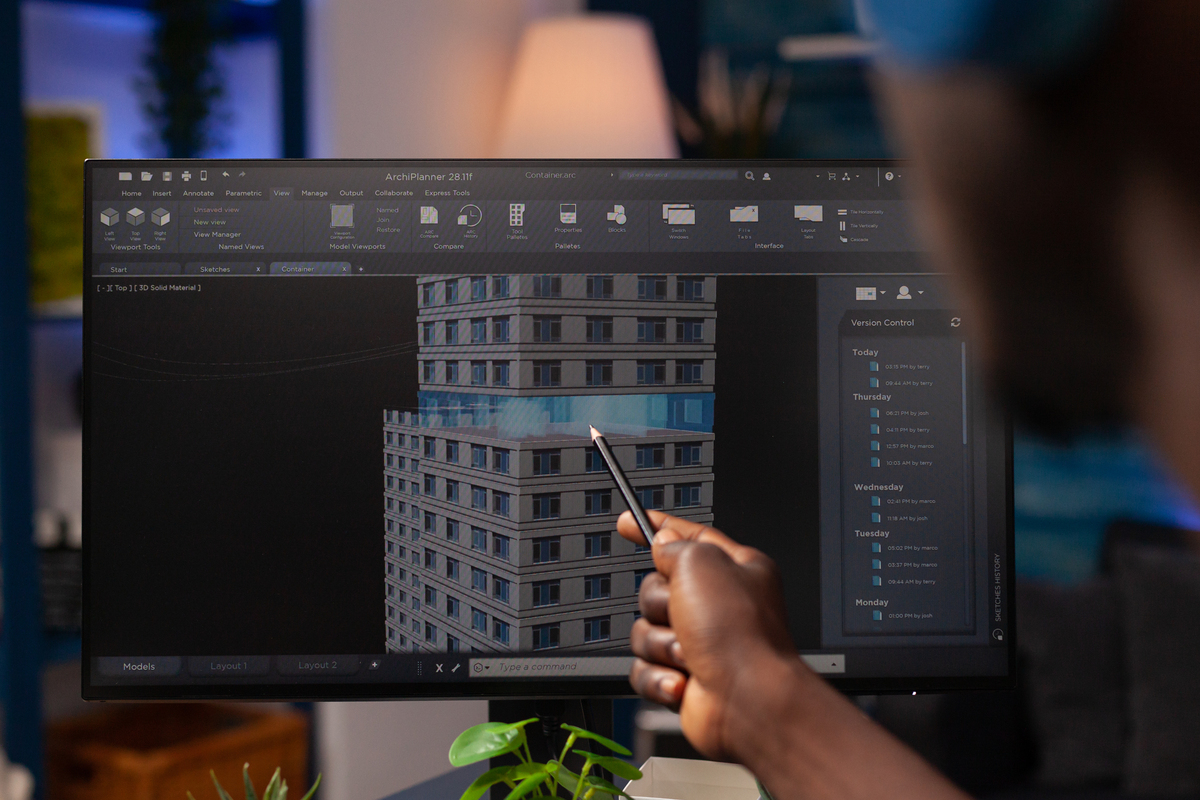
Why is Revit the Most Preferred Software to Create Scan to BIM Solutions?
When it comes to creating scans to BIM models, Autodesk Revit is one of the most used technologies in the AEC sector. It is explained by a number of Revit’s characteristics, including
- Better Visualization: When constructing BIM models, modelers can obtain precise information about building parts from scan data thanks to 360-degree visualization.
- Multiple Prototypes: To prepare for renovation and alteration projects, architects can use the Revit-created model as a base model straight away.
- Analysis and Simulation: Additional analysis and simulations of other elements, like energy usage or accessibility, can be performed using the Revit model. Among other things, it can generate 4D construction deliverables and 2D construction drawings.
- Improved Cooperation: Team members can operate together in a shared model with the aid of Revit collaboration features. As a result, there are fewer conflicts and better coordination across different building disciplines and stakeholders.
- Accurate Measurements and Supporting Evidence: The Revit-created BIM model can be scanned in both directions. Any change made to the model, no matter how little, automatically updates all relevant component dimensions and documentation.
Advice and Techniques for Precise Scan to BIM Solutions
Scan to BIM solutions is an effective technique that may be used for many different tasks, such as building maintenance, refurbishment, and renovation. However, in order to get the desired outcomes and deliverables, it must be done precisely.
1. Using the Appropriate Set of Coordinates to Define the Point Cloud file Format
- Examine the point cloud scan data to address any difficulties with coordination.
- Insert a new point cloud position and coordinates equal to the scan.
- Utilize shared coordinates to establish the basis point.
- To continue working in the original coordinate system, move the basis point around the project coordinates.
- Coordinate accuracy allows for exact Point Cloud visualizations and the necessary graphical behaviors.
2. Align the Point Cloud to Increase Consistency and Mapping
- Gather several points in order to integrate scans.
- Verify the scans’ orientation in the local coordinate system.
- By adding to the conventional and scanned point cloud, alignment and registration problems can be minimized.
- To attain rotational alignment, extrapolate each point while maintaining its density and orientation.
- After the rotational alignment is finished, align the horizontal and vertical axes.
3. To Improve Scan to BIM Solutions Performance, Eliminate Unnecessary Data from the Scans
- To display the necessary scan data or area, remove the noise from unnecessary data obtained via laser scans.
- It is possible to maintain the necessary aspects of the scans by denoising the Point Cloud in the Recap and exporting a Revit model.
- Denoising can be used to eliminate surface degradation and obtain accurate surface optimization.
Suggested article to read: How much does Scan to BIM Cost? Guide to 2025
4. Analyze Scanned Datasets Against 2D Plans and Images to Improve Consistency, Minimize Rework, and Cut Down on RFIs
- Make use of 360-degree images or 2D plans to compare the scanned dataset.
- Elevation views in the As-Built Cloud can be created by comparing 2D plans and 3D Point Cloud to BIM models with scan data.
- Errors are eliminated, budget and time overruns are decreased, and model manipulation is improved with an integrated model approach.
5. To Expedite Model Processing, Reduce the Size of the Huge Point Cloud
- Before importing data into Revit, denoise the scans to get rid of unnecessary information.
- Put point cloud groupings on worksites to enhance graphical override, file management, and visibility.
- Divide datasets into clusters, then maintain a copy for working with scanned files.
- Create a control model that specifies levels, grids, and coordinates for real-time adjustments.
6. Address Building Orientation to Save Project Duration and Increase Model Accuracy
- Fix issues with orientation by precisely determining your location using True North and Google Maps.
- Determine topographic features for evaluation and identification using Google Earth.
- To increase 3D model consistency, develop and identify component libraries for doors, windows, and other elements.

Future Scope
As Scan to BIM solutions have evolved, several new technologies have also surfaced. The range of applications for these technologies has expanded in tandem with a notable decrease in scanning time. The most recent technologies are:
1. LIDAR
A tool that uses LIDAR technology to achieve 3D space scanning is called a LiDAR 3D scanner. In order to measure the distance between the sensor and the object, it fires several laser beams. Its uses include mapping the earth’s surface, evaluating data about the ground, constructing an object’s digital twin, and describing a variety of geographical data. The following categories apply to LiDAR’s practical uses:
- The Environment: These applications include coastal erosion monitoring, forestry carbon stock mapping, and flood risk mapping.
- Automotive: Autonomous vehicles can be navigated with the aid of smaller, low-range LiDAR sensors.
- Space Travel: It’s interesting to note that NASA has determined that LiDAR is essential to their ability to securely land lunar vehicles.
2. Mobile Laser Scanning
This technique for land surveying uses a laser system that is installed on moving vehicles, such as cars, trucks, buses, and even unmanned aerial vehicles (UAVs). The primary applications for this scanning procedure are in the fields of infrastructure, cityscapes, and landscapes.
The advantages of laser scanning on-site:
- No GPS Needed: GPS is not necessary for the alignment and recording of contemporary mobile laser scanning devices. The simultaneous localization and mapping (SLAM) technique is used to accomplish this.
- Time Saved: When capturing a building with a terrestrial laser scanner (TLS), it is necessary to repeatedly arrange the scanner position, set it up, and take it down. This extra time can be saved by using a mobile laser scanner. Mobile mapping equipment typically provide a 10X speed increase over terrestrial scanning in common applications.
Conclusion
Digital point clouds that have been laser-scanned are used by building information modeling (BIM) systems. Development, design, and construction teams can access the data as a 3D site or building model created by a workflow or process called “Scan to BIM solutions.” These swiftly assembled models offer precise visual perception and fine-grained spatial awareness.
Automating most of the building documentation and reality capture process helps with site documentation for new construction projects; for renovation or adaptive reuse projects, it helps with getting a complete understanding of the existing infrastructure. Scan to BIM solutions are a crucial component of the BIM process, and its expansion is directly tied to how often it is used in building maintenance and construction.
An additional factor reducing entrance hurdles for AEC professionals thinking about Scan to BIM solutions is point cloud technology’s increasing usability and accessibility. Similar to BIM, scan to BIM solutions enables confident collaboration amongst stakeholders at all project levels, including surveyors, project managers, building teams, engineers, interior designers, and architects.
Making a sophisticated digital twin of a building is comparable to Scan to BIM solutions. Using lasers, the building is first fully scanned, and then computer magic is used to create a comprehensive model that facilitates interaction with the actual structure. By recording site features with 3D laser scanning equipment, BIM technology creates digital representations of places.
Scan to BIM solutions is a time and money saving platform that allows for real-time revisions, which improves efficiency and collaboration among stakeholders. This crucial phase in the BIM process helps AEC professionals by lowering entry barriers and increasing collaboration at all project levels.
Suggested article for reading:
World’s 10 Best BIM Projects; 2025 Review
What Is Open BIM? Comprehensive Guide 2025
Resources:
TrueCadd | Navvis | Autodesk | Medium | Novatr | Miviso | Gruner | SevernPartnership | Linkedin | Navvis
For all the pictures: Freepik