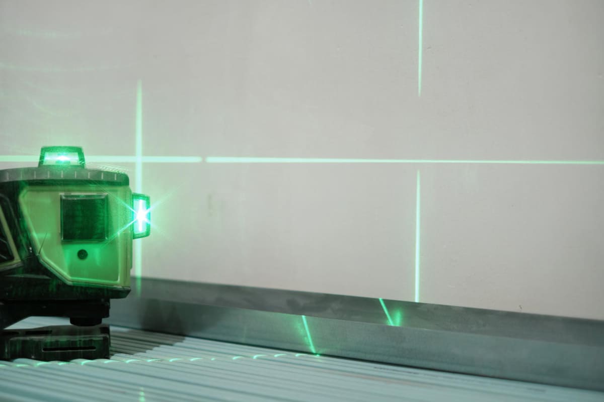
Autonomous construction equipment relies on precise sensing and smart control. Integrating LiDAR with robotics transforms heavy machinery into self-aware, self-navigating vehicles. For example, combining laser scans with cameras and GPS allows machines to map work zones, spot obstacles, and follow design plans automatically. This synergy of robotic and LiDAR sensor integration improves efficiency, safety, and accuracy on site.
Leading manufacturers report major productivity gains: autonomous haul trucks equipped with LiDAR have moved millions of tons with >99.9% uptime and 20% higher daily output than manned trucks, all without injuries (a level of performance only possible through integrated sensing). In the sections below, we examine six key ways LiDAR is fused with robotics for construction tasks, using real-world examples and practical detail.
Table of Contents
Top 6 Robotic and LiDAR Sensor Integrations
1. 3D Perception Through LiDAR and Vision
Integrating LiDAR (light detection and ranging) with cameras and vision sensors gives construction robots a complete understanding of their surroundings. LiDAR provides precise distance and 3D shape data, while cameras add texture and color for object recognition. In practice, a combination of laser scanners and machine-vision software lets a robot distinguish between terrain features, equipment, and people. For example, Boston Dynamics’ Spot robot mounts a LiDAR sensor along with RGB cameras to build a live 3D model of a construction site. By fusing these inputs, the system can detect dynamic obstacles like moving equipment or workers even in low light or dusty conditions, where cameras alone struggle.
-
Advantages of LiDAR+Vision
-
LiDAR yields accurate 3D point clouds for depth and structure, while cameras capture high-resolution detail for classification.
-
Fusion algorithms use LiDAR’s distance data to improve camera-based object detection (e.g. recognizing machinery or safety vests at precise locations).
-
This redundancy boosts reliability: if vision is impaired (e.g. fog or dust), LiDAR still “sees” obstacles, and vice versa for dark or shadowed areas.
-
By integrating LiDAR with visual sensors, robots can perform tasks like navigation and mapping with fewer errors. For instance, modern excavators use LiDAR and cameras together: the LiDAR scans the jobsite to create a 3D grid, and cameras identify surface features and markers. A control computer merges these streams, so the machine can accurately follow a dig plan. If an unexpected object (like a pile of debris) appears, LiDAR immediately registers it, and vision confirms whether it is a worker or material. The combined sensor data enables smooth path planning and ensures that robotic excavators or dozers only follow the intended grading path
Suggested article to read: What is Robotic Material Handling? 2024 Guide

2. Precision Navigation: LiDAR Combined with GNSS/IMU
LiDAR also complements positioning sensors to guide construction machines. GPS (GNSS) gives global location, but its accuracy can vary; inertial sensors (IMUs) track motion. When LiDAR’s 3D scans are added, the system can localize itself on a detailed map. For example, a bulldozer equipped with LiDAR and a GPS+IMU system can achieve centimeter-level accuracy in grading a roadway. The sensors work together: LiDAR captures the terrain profile in real time, IMUs monitor the vehicle’s tilt and movement, and GPS provides base coordinates. Sensor fusion algorithms continuously match the LiDAR scan against the planned terrain model, correcting GPS drift or IMU error.
-
Sensor Fusion for Navigation
-
RTK-GNSS + LiDAR: Real-Time Kinematic GPS gives ~2 cm accuracy under good sky view; LiDAR refines this by matching landmarks and ground features.
-
IMU + LiDAR: An inertial unit absorbs shock and records attitude changes. If dust or obstructions block GPS, LiDAR and IMU maintain orientation via dead reckoning.
-
Continuous Mapping: As a robot moves, LiDAR builds or updates a site map. The system aligns new scans to the existing map, effectively “odomtery without wheels.”
-
For example, in automated road construction, an inertial navigation system (INS) partnered with LiDAR allows an excavator to operate at night or under tree cover. The INS tracks the machine’s motion smoothly while LiDAR periodically corrects any drift by scanning reference points (stakes or design-model outlines). The result is highly precise grading and excavation, even on uneven or changing terrain. Construction companies report that this integration minimizes rework: machines consistently maintain the target depth or slope with very little human input.
Drones equipped with both LiDAR and RTK-GNSS take this concept further: they fly over a site daily, merging LiDAR point clouds with GPS coordinates to produce centimeter-accurate digital twins. These models guide ground robots to within a few centimeters of the planned location, enabling tasks like piling or material placement to happen precisely as designed.
3. Autonomous Earthmoving Robots: Excavators and Dozers
Heavy machines like excavators and dozers become autonomous when fitted with LiDAR and advanced control systems. In these robots, LiDAR sensors (often mounted on the cab or boom) continuously scan the work area while cameras and encoders monitor the tool position. The robot’s software compares the LiDAR map with digital site plans to make decisions. For instance, an autonomous trenching excavator might use LiDAR to detect ground edges and ensure each scoop follows the blueprint. As each load of earth is scooped, the sensors rescan to confirm the cut’s depth and volume.
-
Key Components in Autonomous Earthmoving
-
LiDAR Scanners: Provide 360° awareness. Some machines use rotating 3D LiDAR for long-range detection, plus short-range solid-state LiDAR for fine detail.
-
Joint Angle Sensors: Track the arm and bucket orientation. Combined with LiDAR data, they help compute the exact position of the digging tool.
-
Onboard Computers: Run SLAM (Simultaneous Localization and Mapping) and obstacle avoidance algorithms in real time.
-
A real example is the “Hydraulic Excavator for an Autonomous Purpose” (HEAP) built by researchers at ETH Zurich. This 12-ton excavator used multiple cabin- and arm-mounted LiDAR units, cameras, GPS, and IMUs to place nearly 1,000 stones into a wall autonomously. Each stone was laser-scanned to update a 3D inventory, enabling the excavator to precisely pick and place pieces to build the structure. This case demonstrates how LiDAR on a robotic arm can measure both the environment and materials.
In production, equipment makers like Komatsu and Caterpillar integrate LiDAR into excavators and bulldozers. The LiDAR continually checks the ground profile and alerts the control system if the machine deviates from the plan. For example, Caterpillar’s autonomous dozer projects use LiDAR to detect obstacles in the blade’s path; if a person or object is too close, it automatically stops or reroutes. Thanks to these integrated sensors, autonomous earthmoving vehicles can keep working through the night, cut slope errors by a large margin, and require far less human supervision. In practice, this means a single team of supervisors can manage multiple machines, each safe-guarded by its LiDAR network.
4. Heavy Haul Trucks and Material Transport
Large mining and construction haul trucks benefit greatly from LiDAR integration. These vehicles travel long cycles hauling materials, so safety and reliability are critical. Modern autonomous haul trucks use arrays of LiDAR units (often on front and rear) plus GPS and radar to drive themselves in open-pit mines. The LiDAR sensors create a 3D point cloud of the roadway ahead, detecting trucks, loaders, or workers on the haul road. This allows high-speed response: for example, Caterpillar’s 300-ton autonomous trucks can cruise at 60 km/h because their LiDAR provides 300+ meter look-ahead to brake in time.
-
Autonomy Stack for Haulers
-
Long-range LiDAR: Mounted high on the cabin, gives wide forward coverage. Even at top speed, it maps the road surface and obstacles.
-
Multiple Sensors: Trucks also carry inertial units and GPS for localization, and sometimes RADAR for all-weather detection of large objects.
-
Fleet Management Software: The LiDAR data feeds into a control center (or onboard AI) that integrates with haul road maps and task assignments.
-
Industry data show how effective these systems are. Caterpillar reports its autonomous fleet has run over 400 million tons of rock with zero lost time due to human error, operating 2.5 hours more per day on average than manned trucks. Komatsu’s FrontRunner system similarly uses LiDAR sensors provided by Ouster on its 930E trucks. A 2025 press release noted that Ouster’s high-performance 3D LiDAR (REV7 series) will replace older 2D scanners in Komatsu’s mining trucks, boosting detection range and robustness. The benefit is clear: long-range, high-resolution LiDAR detects tiny obstacles (like a rock fall or stray equipment) very early, allowing safe, high-productivity operation.
In addition to haul trucks, smaller transport vehicles like forklifts and tractors are also getting LiDAR. For example, an autonomous loader at a concrete plant uses LiDAR for precise navigation among tight pallets of materials. Each time it lifts a load, LiDAR scans confirm the bucket is correctly aligned. If a person steps into a geofenced area, the LiDAR-based safety logic slows or stops the vehicle immediately. Overall, LiDAR’s integration in heavy transport ensures machines can operate continuously with minimal downtime, since they can detect and avoid hazards that would normally halt manual vehicles.
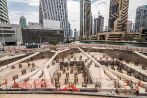
5. Site Surveying and Digital Mapping
LiDAR integration isn’t limited to mobile machines; it powers planning and monitoring too. Drones and robots equipped with LiDAR create detailed 3D maps of a construction site, which feed into project management and control systems. Aerial LiDAR drones can scan large earthworks in minutes, generating digital elevation models or point clouds. These maps are then compared to design models to check progress or volume of stockpiles. Meanwhile, ground robots (like Boston Dynamics’ Spot) carry LiDAR scanners indoors or under bridges to map areas inaccessible to GPS.
-
Mapping and Monitoring
-
Digital Twins: Regular scans build a live “digital twin” of the site. Managers overlay the planned versus actual models to catch deviations early.
-
Volume Calculations: LiDAR point clouds calculate cut/fill volumes for excavation or aggregate, replacing manual survey stakes.
-
Progress Tracking: Autonomy platforms use LiDAR data to show project status in real time, comparing weekly scans to schedule.
-
For example, a construction firm used a LiDAR-equipped drone to scan an open site daily. The scanned data was automatically aligned to the project BIM (Building Information Model). When the laser scans showed an excavation was 10 cm off-target, the team adjusted the machine guidance for the next shift, avoiding a costly rework. Autonomous rovers do similar work on foundations and underground structures; they drive pre-defined routes with LiDAR and feed maps to engineers every night. The result is tighter control: projects finish on time more often because the robotic surveying catches errors before they cascade into delays.
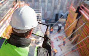
Integrating LiDAR with cloud computing and AI further enhances mapping. Advanced software can stitch together thousands of LiDAR scans into one cohesive 3D model, automatically removing noise and colorizing the point cloud using camera images. Construction managers then review these rich models through tablet apps, highlighting areas that need attention. In this way, robotic LiDAR mapping becomes an essential integration tool – it closes the loop between digital design and real-world execution by giving autonomous equipment up-to-date “eyes” on the project conditions.
6. Safety and Collision Avoidance Systems
Worker and site safety is a top priority, and LiDAR is integral to achieving it in autonomous machinery. By continuously scanning the nearby environment, LiDAR-equipped robots create virtual “safety cages.” If a person or obstacle enters a danger zone, the system reacts instantly. For instance, Caterpillar’s Cat® Detect system uses mounted LiDARs around loaders and dozers. When the laser beams detect a worker in the vehicle’s blind spot, the system warns the operator and can even apply brakes. Similarly, Komatsu’s Smart Construction platform uses LiDAR data to track equipment positions in real time, alerting operators if their paths might collide.
-
How LiDAR Improves Safety
-
Real-time Object Detection: 3D LiDAR spots people, vehicles, and barriers with centimeter precision, even in darkness or bad weather.
-
Automated Braking & Alarms: Sensor fusion logic processes LiDAR data to trigger immediate vehicle slowdown or stop before impact.
-
Zone Enforcement: Project planners define no-go zones (e.g. pedestrian walkways); LiDAR-equipped machines autonomously avoid entering those areas.
-
Beyond vehicle-mounted LiDAR, some sites use stationary LiDAR scanners to guard perimeters. These fixed units monitor entire work zones and notify machines (and workers) of encroachments into hazardous areas. For example, a fixed LiDAR panel near a deep excavation can sense if heavy equipment is too close to the ledge or if a human falls in, triggering an alert. In tunnels and trenches where GPS fails, LiDAR on both manned and unmanned machines ensures no one can wander out of sight.
In practice, this integration of LiDAR and robotics means machines can operate faster and more aggressively, because the risk of unseen obstacles is dramatically reduced. As one construction manager noted, “With LiDAR scanning 20 times per second around the machine, we gained trust to work night shifts knowing the system will catch hazards before we even see them.” These capabilities – crowd detection, collision avoidance, geofencing – are only possible when LiDAR sensors and control systems are tightly integrated into the robotic machinery.
FAQs
How does LiDAR enhance safety on construction sites?
LiDAR provides real-time 3D scanning around machinery, detecting workers and obstacles even in poor visibility. Systems like Caterpillar’s Cat Detect use LiDAR to warn or automatically stop equipment before collisions, greatly reducing risk and improving site safety.
What roles do sensors like GPS and IMUs play with LiDAR integration?
GPS (often with RTK) and IMUs supply coarse positioning and motion data, while LiDAR adds detailed local mapping. Together they enable centimeter-level navigation on uneven terrain. For example, a bulldozer uses RTK-GPS plus LiDAR scans to grade a road exactly to plan.
Which construction machines benefit most from LiDAR integration?
Heavy autonomous equipment – such as excavators, bulldozers, and haul trucks – see big gains from LiDAR. These machines use LiDAR for obstacle avoidance, mapping, and precision work (grading or digging). Drones and rovers also use LiDAR for site surveying and progress monitoring.
Is it true that LiDAR can allow equipment to run without human supervision?
When properly integrated, LiDAR lets equipment detect hazards and follow plans autonomously, but human oversight remains important. LiDAR-based autonomy has enabled trucks and excavators to work many extra hours without incident, but operators still set goals and intervene for complex situations.
Conclusion
Robotic and LiDAR sensor integration is rapidly transforming construction equipment into self-aware, highly efficient systems. By fusing LiDAR with cameras, GPS/IMU, and intelligent control, machines can navigate complex sites, avoid hazards, and carry out tasks with precision that humans alone cannot match. Real-world implementations by companies like Komatsu, Caterpillar, and innovative tech firms have already demonstrated large gains in productivity, safety, and cost savings. In short, LiDAR-enabled robotics is no longer a futuristic idea – it is the practical core of today’s autonomous construction fleet.
Resources:
Ouster, Inc. (2025). Ouster to Supply Lidar Sensors for Komatsu’s Suite of Autonomous Offerings. Available at:
Communications of the ACM. Kirkpatrick, K. (2018). Autonomous Construction Vehicles Are Building the Future.
Lidar News. (2025). Harsh Environment LiDAR – Challenges and Solutions. Available at:
SBG Systems. (2023). Inertial solutions for autonomous construction machinery.
DroneDeploy. (2021). Use robots to autonomously scan construction sites.
For all the pictures: Freepik
Suggested article for reading:
6 Examples of Robotic Bricklaying and On‑Site Assembly in Construction
10 Government Policies for Solar Panels into New Builds in 2025
5 Ways AI is Revolutionizing Asset Tracking and Management
6 Must-know AI Tools for Construction Managers
5 Real‑World Applications of BIPV: From Facades to Canopies
10 Ways of Integrating Digital Twin Technology with Fabrication Workflows