

Photogrammetry in restoration, provides an innovative approach to capturing and preserving cultural heritage. This technique, which creates detailed 3D models from photographs, is being increasingly adopted across various disciplines. A testament to its growing significance, the global photogrammetry market is projected to reach $1.9 billion by 2025, reflecting a compound annual growth rate (CAGR) of 15.7% from 2020.
The method involves capturing multiple overlapping images of an object or site from different angles and processing these images with specialized software to generate accurate 3D representations. This digital documentation is invaluable for restoration efforts, offering precise measurements and visualizations that facilitate the maintenance and reconstruction of historical structures and artifacts.
Photogrammetry’s non-invasive nature makes it particularly suitable for delicate and inaccessible objects, ensuring their preservation without physical contact. Applications of this technology span from architectural restoration and art conservation to archaeological site documentation and urban planning.
Despite its benefits, photogrammetry also faces challenges, such as technical limitations, environmental factors, and the need for specialized expertise. However, with advancements in technology and increasing accessibility, photogrammetry continues to play a crucial role in preserving our cultural and historical heritage, enabling detailed analysis and collaborative efforts in restoration projects worldwide.
Table of Contents
What is Photogrammetry?
Photogrammetry is a technique used to obtain precise measurements and create detailed models from photographs. By capturing multiple images from different angles, photogrammetry allows for the extraction of three-dimensional information from two-dimensional data. This method relies on the principles of geometry, optics, and computer vision to analyze and reconstruct the shape, dimensions, and spatial relationships of objects.
The process begins with data collection, where images are taken using cameras, drones, or other imaging devices. These images overlap significantly to ensure all aspects of the object or scene are captured. Specialized software then processes the images, identifying common points and features across them. By triangulating these points, the software creates a detailed 3D model, which can be further refined and analyzed.
Suggested article to write: The Importance of Drones in Construction: 7 Key Reasons
Photogrammetry has applications across various fields, including surveying, archaeology, architecture, and forensics. In restoration, it plays a crucial role in preserving cultural heritage. For instance, photogrammetry can document the current state of a historical structure, aiding in its maintenance and restoration by providing accurate, up-to-date models. These models are invaluable for planning restoration efforts, as they offer a precise reference that helps conservators understand the original appearance and condition of the object or site.
The non-invasive nature of photogrammetry makes it particularly suitable for delicate or inaccessible objects, ensuring their preservation without physical contact. As technology advances, photogrammetry is becoming more accessible and cost-effective, making it an indispensable tool in both professional and academic settings for capturing and preserving the physical world in remarkable detail.

Applications of Photogrammetry in Restoration
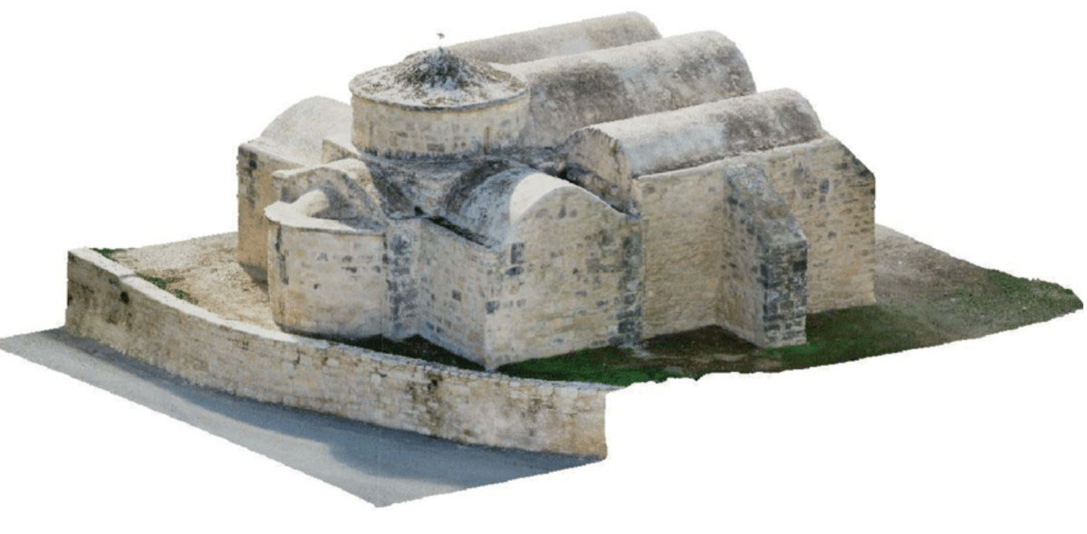
Cultural Heritage Preservation: Photogrammetry is extensively used in the preservation of cultural heritage sites. It allows for the creation of detailed 3D models of historical structures and artifacts, capturing their current state with high precision. These models serve as digital records that can be used for future restoration projects or for educational purposes. For example, photogrammetry has been employed in the documentation of ancient ruins, ensuring that their current condition is meticulously recorded before any further degradation occurs.
Architectural Restoration: In architectural restoration, photogrammetry provides accurate measurements and detailed visualizations of buildings and structures. This is particularly useful for restoring historical buildings where original blueprints might be unavailable or damaged. The 3D models generated through photogrammetry help architects and conservators understand the exact dimensions and details of the structure, facilitating accurate restorations. This method has been successfully applied to restore iconic structures like cathedrals, castles, and other heritage buildings.
Art Restoration: Photogrammetry is also revolutionizing the field of art restoration. It allows conservators to create precise replicas of artworks, which can be used for restoration or preservation. For instance, detailed 3D models of sculptures, paintings, and other artifacts can be generated to study their surface textures and identify areas that need restoration. These models also enable virtual restoration, where conservators can test different restoration techniques digitally before applying them to the actual artwork.
Suggested article to read: Top 7 Digital Twin Software in 2025
Archaeological Site Documentation: In archaeology, photogrammetry is invaluable for documenting excavation sites and artifacts. It provides a non-invasive way to capture the spatial relationships and details of archaeological finds. The resulting 3D models can be analyzed and shared with researchers worldwide, promoting collaborative study and preserving the site’s information for future generations. This technique has been used in documenting everything from ancient burial sites to entire archaeological digs, ensuring that even the most fragile artifacts are preserved in digital form.
Urban and Environmental Restoration: Photogrammetry aids in urban and environmental restoration by providing detailed maps and models of landscapes and urban areas. This is particularly useful in restoring areas affected by natural disasters, where accurate data on the terrain and existing structures is crucial for planning and executing restoration efforts. The technology helps in assessing damage, planning reconstruction, and monitoring progress over time.
Digital Archiving and Virtual Tours: Photogrammetry enables the creation of digital archives and virtual tours of historical sites and artifacts. This not only aids in preservation but also makes cultural heritage more accessible to the public. Virtual tours allow people to explore historical sites and museums from anywhere in the world, promoting education and awareness. These digital archives ensure that even if physical structures are lost, their digital replicas remain available for study and appreciation.
Overall, photogrammetry is transforming the field of restoration, providing precise, non-invasive, and cost-effective solutions for preserving our cultural and historical heritage. Its applications span a wide range of areas, each contributing to the meticulous documentation and restoration of invaluable artifacts and sites.
How Photogrammetry Works
Data Collection: The process of photogrammetry begins with data collection, where multiple photographs of an object or scene are taken from different angles. These images can be captured using various equipment such as standard cameras, drones, or specialized photogrammetric cameras. The key is to ensure significant overlap between the photos, typically around 60-80%, so that the same points can be identified in multiple images. This overlap is crucial for accurate 3D reconstruction.
Image Alignment: Once the images are collected, they are imported into photogrammetry software. The software analyzes the images to detect common features and match points across different photos. This process, known as image alignment, involves identifying identical points in overlapping images and aligning them accurately. The software uses these matched points to establish the spatial relationship between the images.
Point Cloud Generation: After the images are aligned, the software generates a point cloud, which is a collection of data points in 3D space representing the surface of the object or scene. Each point in the cloud corresponds to a specific point in the real world. The software uses algorithms based on triangulation, where the distance between matched points in different images is calculated to determine their exact 3D coordinates. This step converts the 2D image data into a 3D spatial representation.
Suggested article to write: Scan to BIM Software; Ultimate Guide for Point Cloud to BIM Modelling
Mesh Creation: The point cloud is then processed to create a mesh, which is a network of interconnected triangles that define the shape of the 3D model. The mesh provides a more structured and continuous surface representation of the object or scene. This step is crucial for producing a detailed and accurate 3D model that can be further refined and analyzed.
Texturing: After the mesh is created, the next step is texturing. The original photographs are used to apply textures to the mesh, adding color and detail to the 3D model. This makes the model visually realistic and true to the appearance of the original object or scene. Texturing involves mapping the 2D images onto the 3D mesh, ensuring that all surface details are accurately represented.
Output and Analysis: The final output of the photogrammetry process is a detailed 3D model that can be used for various purposes, such as analysis, restoration, documentation, or visualization. These models can be exported in various formats compatible with different software used in fields like architecture, archaeology, and engineering. The 3D models allow for precise measurements, detailed inspections, and virtual manipulations, making them invaluable tools for restoration and preservation projects.
Refinement and Integration: In some cases, the 3D model may undergo further refinement to enhance accuracy and detail. Advanced software tools can be used to clean up the model, fill in gaps, and smooth surfaces. Additionally, photogrammetry models can be integrated with other data sources, such as laser scans or CAD drawings, to create comprehensive and highly accurate representations of complex objects or sites.
Photogrammetry’s ability to convert simple photographs into detailed 3D models makes it a powerful tool in restoration and preservation, offering a non-invasive and highly accurate method for documenting and analyzing cultural heritage, architectural structures, and archaeological sites.
Benefits of Using Photogrammetry in Restoration
Accuracy and Precision: Photogrammetry provides exceptionally accurate and precise measurements, which are crucial for restoration projects. By creating detailed 3D models, it ensures that every aspect of an object or structure is meticulously documented. This high level of detail aids restorers in understanding the original dimensions and features, allowing for more faithful and accurate restorations.
Cost-effectiveness: Photogrammetry is a cost-effective solution for documenting and analyzing restoration projects. Traditional methods, such as manual measurement and drawing, can be time-consuming and expensive. Photogrammetry reduces labor costs and speeds up the data collection process. The technology itself is becoming more affordable, making it accessible to a wider range of projects, including those with limited budgets.
Suggested article to read: Cost Overruns in Construction Projects; Guide to 2025
Non-invasive and Non-destructive: One of the most significant benefits of photogrammetry is its non-invasive nature. It allows for detailed examination and documentation without physically touching or altering the object or site. This is particularly important for fragile or sensitive artifacts and structures, where physical contact could cause damage. Photogrammetry ensures that the integrity of the subject is preserved throughout the restoration process.
Comprehensive Documentation: Photogrammetry provides a comprehensive and permanent digital record of the current state of an object or site. This documentation can be invaluable for future reference, allowing restorers to track changes over time and compare different stages of restoration. Detailed 3D models and maps generated through photogrammetry serve as an essential archive for ongoing and future conservation efforts.
Suggested article to read: 24 Types of Construction Documents
Enhanced Visualization and Analysis: The 3D models created using photogrammetry offer enhanced visualization capabilities, allowing restorers to examine the subject from various angles and zoom in on specific details. This level of analysis is difficult to achieve with traditional 2D drawings and photographs. The ability to visualize the object in three dimensions helps restorers better understand the structure and identify areas that require attention.
Facilitation of Remote Collaboration: Photogrammetry enables remote collaboration among restoration experts. High-quality 3D models can be shared digitally with specialists around the world, allowing for collective analysis and decision-making without the need for physical presence. This facilitates a more collaborative and informed approach to restoration, incorporating insights from various experts.
Time Efficiency: Photogrammetry significantly speeds up the documentation process. Traditional methods of recording details of a restoration project can take days or even weeks, whereas photogrammetry can capture the necessary data in a matter of hours. This time efficiency translates to faster project turnaround times and the ability to address urgent restoration needs more promptly.
Reproducibility and Repeatability: The data collected through photogrammetry is reproducible and repeatable. If additional information is needed or if re-evaluation is required, the same data set can be reprocessed without having to return to the site. This ensures that restorers have consistent and reliable data throughout the duration of the project.
Integration with Other Technologies: Photogrammetry can be easily integrated with other technologies, such as laser scanning, CAD, and Building Information Modeling (BIM). This integration allows for a more comprehensive approach to restoration, combining the strengths of different methods to achieve optimal results. For instance, combining photogrammetry with laser scanning can enhance the accuracy and detail of the 3D models.
Overall, photogrammetry offers numerous benefits in the field of restoration, making it an indispensable tool for preserving cultural heritage, architectural landmarks, and historical artifacts. Its accuracy, cost-effectiveness, non-invasive nature, and ability to facilitate collaboration and detailed analysis make it a preferred method for modern restoration projects.

Challenges and Limitations
Here’s the list of challenges and limitations of implementing photogrammetry in restoration:
Technical Limitations
- Resolution and Accuracy: While photogrammetry provides high-resolution models, its accuracy can be limited by the quality of the input images. Factors such as lighting conditions, camera quality, and image overlap significantly affect the precision of the final model. In some cases, laser scanning may offer higher accuracy, especially for capturing fine details.
- Complex Geometries: Photogrammetry can struggle with complex geometries and reflective or transparent surfaces. These surfaces can create challenges in capturing accurate data, leading to incomplete or distorted models.
Environmental Factors
- Lighting Conditions: Photogrammetry relies heavily on good lighting to capture clear and detailed images. Poor lighting conditions, such as shadows or excessive brightness, can lead to inaccurate data. This limitation makes it difficult to use photogrammetry effectively in all environments.
- Weather Conditions: For outdoor projects, weather conditions can pose significant challenges. Rain, fog, and strong winds can affect image quality and the stability of equipment like drones, leading to poor data collection.
Skill and Expertise Requirements
- Technical Expertise: Successful implementation of photogrammetry requires a certain level of technical expertise in both photography and software operation. Users must be proficient in capturing high-quality images and processing them accurately using specialized software.
- Learning Curve: There is a learning curve associated with mastering photogrammetry tools and techniques. This can be a barrier for individuals or organizations new to the technology, requiring time and training to become proficient.
Cost and Accessibility
- Initial Investment: Although photogrammetry is cost-effective in the long run, the initial investment in high-quality cameras, drones, and software can be substantial. This can be a limitation for smaller projects or organizations with limited budgets.
- Software Costs: Professional photogrammetry software can be expensive, and ongoing costs for licenses and updates can add up. Free or low-cost alternatives exist but may not offer the same level of functionality and accuracy.
Data Management
- Large Data Sets: Photogrammetry generates large data sets, including high-resolution images and detailed 3D models. Managing, processing, and storing this data requires significant computational resources and storage capacity.
- Data Processing Time: The time required to process photogrammetric data and generate 3D models can be lengthy, especially for large projects. This can slow down the overall restoration process.
Limitations in Capturing Detail
- Surface Detail: Photogrammetry may not capture very fine surface details as accurately as other methods like laser scanning. This limitation can be critical in projects where high detail is essential, such as the restoration of intricate artworks or sculptures.
- Scale and Scope: While photogrammetry is effective for capturing objects and small to medium-sized structures, it can be less effective for very large sites or objects. For extensive areas, combining photogrammetry with other surveying methods may be necessary to achieve comprehensive coverage.
Legal and Ethical Considerations
- Privacy Issues: When using drones or capturing images in public or private spaces, there are legal and ethical considerations regarding privacy and permissions. Ensuring compliance with local regulations and obtaining necessary permissions is crucial.
- Cultural Sensitivity: In the context of cultural heritage, it is important to approach photogrammetry with sensitivity to the cultural and historical significance of the objects or sites being documented. Engaging with local communities and stakeholders is essential to avoid potential conflicts.
While photogrammetry offers numerous benefits for restoration projects, including accuracy, cost-effectiveness, and non-invasive data collection, it also comes with challenges and limitations. Addressing these requires careful planning, investment in quality equipment and software, and the development of technical expertise. By understanding and mitigating these challenges, restorers can effectively leverage photogrammetry to preserve and restore cultural heritage and historical artifacts.
Conclusion
Photogrammetry stands out as a transformative tool in the field of restoration, offering precise, cost-effective, and non-invasive methods for documenting and preserving cultural heritage. By converting simple photographs into detailed 3D models, photogrammetry enables restorers to capture accurate representations of historical structures, artifacts, and archaeological sites. This technology enhances the ability to visualize and analyze objects from multiple angles, facilitating informed restoration decisions and comprehensive documentation.
Despite its numerous benefits, photogrammetry also presents certain challenges. Technical limitations, such as resolution and the difficulty of capturing complex geometries, can affect accuracy. Environmental factors like lighting and weather conditions can impede data collection, while the need for technical expertise and significant initial investment may pose barriers for some projects. Additionally, managing large data sets and ensuring compliance with legal and ethical standards require careful planning and resources.
By addressing these challenges through investment in quality equipment, training, and proper planning, restorers can maximize the potential of photogrammetry. Its integration with other technologies, such as laser scanning and CAD, further enhances its capabilities, making it an indispensable tool for modern restoration efforts. As technology advances, photogrammetry will continue to play a crucial role in preserving our cultural and historical heritage, ensuring that future generations can study and appreciate these invaluable assets.
Suggested article for reading:
10 Best Construction AI Software in 2025
10 Best Construction Accounting Software Programs in 2025
11 Best Architectural Modelling Software; 2025 Review
Resources:
National Institute of Health | Taylor & Francis Online | Cell Press | ResearchGate | Willy Online Library
For all the pictures: Freepik